Basic Geography and Overview of Isabela Island
 |
| Map of Isabela from JunglePhotos.com Map reproduced with permission from Instituto Geografico Militar del Ecuador |
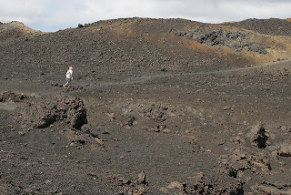 |
| Landscape/Moonscape on Isabela Hiking Up Volcan Sierra Negra Photograph from CreativeCommons by Michael R. Perry |
Isabela is also unique because it grew not from one volcanic eruption, but by the integration of six separate underwater volcanoes. It is the largest land mass in the island system, accounting for 60% of the total land area. Moreover, due to its size and the fact that it arose from the sea as a result of multiple different natural occurrences and eruptions, its landscape is varied and it has many individually interesting tour sites and attractions.
This is the first of three posts I will write about Isabela Island. Here, I focus on the remarkable visitor sites accessible from the main town of Puerto Villamil. Get ready - you are about to experience everything from blue footed boobies to steps carved into a volcanic hillside, from flamingos to a bustling town. Indeed, each visitor to Isabela will experience this enchanted ground from a difference perspective, and, like the Galapagos Islands themselves, Isabela has something to offer everyone.
 |
| Beautiful Sunset over Isabela Island Photograph from Creative Commons by Acme |
Puerto Villamil
 |
| Puerto Villamil Panorama Photograph from CreativeCommons by Flurdy |
 |
| Iquanas Watching the Sunset at Puerto Villamil Photograph from CreativeCommons by Michael R. Perry |
 |
| Dock and Sunset at Puerto Villamil Photograph from CreativeCommons by Acme |
You will find the main port surrounded by extensive, white sandy beaches with lagoons and wetlands on its borders. The nearby sites, to which I provide more in depth information below, include Flamingo Lake, Mango Viewpoint, the Tortoise Breeding Station, the Wall of Tears, the Wetlands lagoons, Cueva de Sucre, Las Tintoreas, Concha de Perla and many swamps and mangroves, which are the home to a variety of bird species.
Flamingo Lake
 |
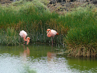
| Flamingo Lake |
All photographs of Flamingo Lake are from Creative Commons courtesy of, respectively, NH53, Dallas Krentzel, jdegenhardt, ccarlstead, jdegenhardt and sly06. Thank you all for sharing these beautiful representations of this gorgeous Galapagos visitor site.
 |
The Wetlands
 |
| Entrance to Isabela Wetlands All Wetlands Photographs from Galapagos National Park Service |
The Galapagos National Park Service has an excellent description of the Wetland sites surrounding and nearby Puerto Villamil. It describes the Wetlands as a complex of trails that include the following sites:
Cerro Orchilla: From this lookout point, accessible via a staircase, you can see spectacular scenery including the bay and the town of
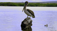
 El Estero: This is 227 meter path of lava rocks, 1.5 meters wide. Here, you are free to picnic and view the scenery and wildlife. This is a particularly important trail because of its juxtaposition to the mangrove eco-systems of Isabela Island. Four species of mangrove are present, including the largest black mangrove trees anywhere in the Galapagos. There is also a small majagual forest. El Estero is related to the stories and legends of the penal colony era on Isabela. There is also a freshwater spring that, at low tide, forms a river that flows into a sandy bay for observation of sea birds and marine life.
La Poza Escondida: The main attraction along this path of stone and wood is a mangrove forest.
 Poza Redonda: This equally beautiful pathway, 50 meters long, is comprised of lava plates leading to a pool formed inside a collapsed lava tube.
 Tunel del Estero: Another lava tunnel will be found at the culmination of this 75 meter path consisting of lava plates and ending in a staircase. Above the tunnel you can see the intertidal landscape that offers a tapestry of Galapagos Sesuvium between "El Túnel del Estero" and
 Love
 Los Tunos Viewpoint and Pozas Verde: These two paths have several lookout points for observation of bird and plant life.
La Playita: This path leads to a small beach that is part of the greater beach in Villamil.
Mangrove Trees of the Type found in the Wetlands on Isabela Island:
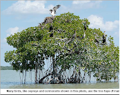 |
| White Mangrove Tree with Ospreys and Cormorants Photograph School of Forest Resources and Conservation University of Florida |
 |
| Mangroves and Root System Creative Commons Photograph by Platours_Flickr |
 |
| Galapagos Mangroves Creative Commons Photograph by Neil Hinchley |
 |
| Mangroves and Root System Creative Commons Photograph by Rouzwawi |
El Mirador del Mango (Mango Viewpoint)
This site is also historically significant in terms of the human development of Isabela. This is the former location of the gravel mine from which the roads and highways on Isabela were constructed. Additionally, the road to Mango Viewpoint was used by early settlers of the island and then by the convicts who arrived to this island.
Arnaldo Tupiza Breeding Center
 |
| Breeding Center Photograph from CreativeCommons by Michael R. Perry |
 |
| Breeding Center Photograph from CreativeCommons by Sly06 |
If you are interested in learning more about the tortoise population at Isabela’s Breeding Center, follow this link to the Galapagos National Park Service’s statistical information.
Wall of Tears
 |
| Approaching the Wall of Tears Photograph from Creative Commons Akeg |
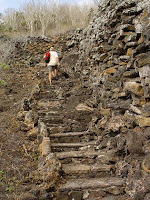 |
| Wall of Tears Photograph from John Santic |
 |
| Wall of Tears Photograph from John Santic |
Cueva de Sucre (Sucre's Cave)
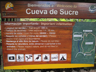 |
| Galapagos National Park Sign at Entrance to Cueva de Sucre |
 |
| Entrance to Cueva de Sucre |
Concho de Perla - Pearl Shell
 |
| Blue Footed Boobies at Concho de Perla Photograph from Creative Commons Taken by Acme |
 |
| Gorgeous Sunset at Concho de Perla Photograph from Creative Commons Taken by Acme |
 |
| Wooden Walkway to Concho de Perla Photograph from Galapagos National Park Service |
 |
| Underwater at Concho de Perla Photograph by Galapagos National Park Service |
The visitors' site Concha de Perla is in Puerto Villamil. It is a public site, no guide required, and a reasonable bicycle ride. In fact, though you cannot ride your bike on the Perla walkway itself, bike racks are provided. Access to the site is by a wooden walkway that runs through a mangrove forest up to an intertidal pond. At this shallow and calm bay, you will see just how crystal clear the water can be. Here you may see sea turtles, penguins, sea lions, many tropical fish and rays. Concha de Perla is structured as a kind of hollow circular enclosure of natural rock, which is fed by the sea with the changing tides. Locals use this site as a place for swimming and snorkeling. In the mangroves and rocks present along the walkway to the Laguna Concha de Perla, there is a small colony of sea lions.
 |
| Concho de Perla Photograph by Galapagos National Park Service |
Las Tintoreras
 |
| Pools at Las Tintoreras All Photographs from the Galapagos National Park Service |
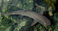 A great site for both snorkelers and photographers is Las Tintoreras, a small stretch of lava islands just moments by panga from the main dock at Puerto Villamil harbor. The name itself means White Tipped Reef Shark and this site is aptly named - you simply won't believe your eyes when you are faced with literally dozens of Sharks swimming in small pools. One of the main pools - actually a narrow channel in which the sharks congregate during high tide - is just about 1 meter deep, so you are really able to see the sharks from above. They seem to be lazing on the bottom, barely moving. Certainly, they are not in a hurry to move away from human visitors to their territory. This is their primary breeding ground - their headquarters so to speak!
 |
| Nolana Galapageia Flower Photograph from WikiCommons |
The trail at Las Tintoreras is AA lava and there are both white and black sand beaches. In addition to the amazing marine life, you may see here a rare endemic plant called Nolana Galapageia. Most of the trail is lava AA, and you will have access to both a white sand beach and a black stone beach.
La Calera
 |
| La Calera All Photographs from Galapagos National Park Service |
La Calera is just minutes by panga from the pier in Puerto Villamil. You will experience a wet landing and then a short trail across some tidal pools. The limestone, sand and stone at La Calera has been used by island settlers as building material. This is a lovely locale in which to snorkel in a quiet lagoon. It is very similar in characteristics to Las Tintoreras.
Sulfur Mines
 |
| Surfur Mines on Isabela Photograph by Galapagos National Park Service |
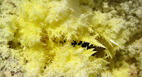 |
| Close Up of Surfur Coloration on Isabela Photograph by Galapagos National Park Service |
 |
| Approaching the Sulfur Mines Photograph from Creative Commons by Flurdy |
This site is rarely visited and not for the faint hearted. It's deep into the interior of Isabela and about a 45-minute drive from Puerto Villamil, then quite a trek on horseback to the site itself. You are allowed to camp and hike at this site, provided you have received permission and are accompanied by a certified guide.
 |
| Steaming Sulfur and Sulfur Formations Photographs from Galapagos National Park Service |
Summary of Visitor Sites on Isabela Island
Isabela Island is a wonderland. In this post, I have provided you just a taste of the diversity and beauty accessible from the town of Puerto Villamil. Now, with your eyes wide open, prepare to be awed by the extraordinary and unique locations that await you as you travel around the island by boat - that will be the focus of soon-to-be published Part Two of my Isabela Island guide. Then, more rapturous and inspiring sites await you at Isabela's six volcanoes, the subject of Part Three.




No comments:
Post a Comment