 |
| San Cristobal Island |
Sunday 16 September 2012
Galapagos Island Geography and Geology - Part Three - Ocean Currents
Friday 7 September 2012
Galapagos Island Geography and Geology - Part Two - Galapagos Volcanoes
 |
| Map Showing Galapagos Islands' Volcanoes from ecuador.us |
 |
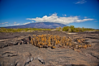
| Shield Volcano, Rugged Lava Rock, Lava Cactus Photograph taken by Aqua Surround |
Wednesday 5 September 2012
Galapagos Island Geography and Geology – Part One – The Tectonic Plates and Hot Spots Created the Volcanic Islands
 |
| The Galapagos Islands The Newest Islands are the Most Westerly The Oldest Islands are the Most Easterly |
This is the first of three posts about the geography and geology of the Galapagos Islands. Each post will take you on a short journey with the explicit intention of providing basic background information about the natural evolution of the Galapagos Islands. These remote islands, unlike anything else on our planet, have a dramatic and ever-changing morphography.
This article - Part One - focuses on the tectonic plates that lie beneath the sea and under the land. For, without the constant movement of the tectonic plates, their crashing into one another, forcing the hot magma to break through the lithosphere, there would be no Galapagos Islands at all. Part Two will discuss the actual formation of the islands from volcanic action that occurs when tectonic plates collide. Each and every one of the Galapagos Islands, their topography, the sheer cliffs that you see and that have become the nesting sites for birds and animal life found no where else on earth, the beautiful outcroppings, SCUBA sites, black sand beaches, crystalline beaches - all is the result of volcanic activity. Finally, in Part Three, I will talk about the Pacific Ocean currents, particularly how the hot and cold currents impact and define the plant, animal, bird and marine life throughout the Galapagos.
Subscribe to:
Posts (Atom)